
This is an attempt to sum up three months and 688 nautical miles from an island in Lake Champlain to an island in Chesapeake Bay. I am reluctant, it takes skill to write a travelogue and not bore. But nothing ventured, nothing gained, so if your eyelids start to close after the second paragraph move on!
Carrie Rose started the year shrink wrapped in an old quarry on Grand Isle, Vermont and ended parked on a field of gravel in a south facing spline of Kent Island, Maryland. A variety of environments as well as ninety-degree heat marked this year’s cruise. What follows is a account of the above journey. So, grab an atlas and follow along with Charlotte and I.

For the first few days of June at Ladd’s Landing Marina Carrie Rose was still on the hard and the boat was the only place for me to stay. I got on and off her by climbing up and down a steep ladder precariously perched next to the stern. Before I put my foot on a rung, I stopped and thought about this simple but fraught with danger procedure. Only then did I begin to climb or descend. The worst was the inevitable pre dawn potty break.
I made it intact to the launching only to have it rain for the rest of the month with several “only once in a season” northeasterly storms. Wind and waves from that quadrant get the marina dancing. It is amazing how many directions a boat can move at once! I made sure Carrie Rose was securely tied to the gyrating dock and rode the storms out, not without a touch of mal de mar.
It was sad to leave Ladd’s Landings. Both Charlotte and I felt we were part of a community. We did not venture far at first, three miles in fact to Burton State Park in the protected waters of the Inland Sea of Lake Champlain. Still, the moorings were open to the north, so after a night we moved to a protected slip and dallied for a week. The bikes, boats, and hiking boots all got used.

When the weather cleared, we headed for a popular mooring field across the Broad Lake in New York. This is open to the south and despite the weather report the winds blew from that direction. It was lumpy but we have grown into tolerant cruisers in the last few years and if conditions are not dangerous, we are thankful.
Our next stop was about 10 miles south to Valcour Island. It is a beautiful bay and was the site of a pivotal naval battle during the Revolutionary War. Against my better judgment, in addition to the main anchor, I placed one off the stern to keep us from swinging in the increasingly crowded anchorage. Retrieving this anchor caused my second low back attack in as many weeks. Damn!
Lake Champlain is 150 miles long. It begins in Canada as the Richelieu River, widens to 15 miles by the time it gets to Burlington, Vermont, and narrows again to a slip of a river where at Lock 12 the Champlain Canal begins. The Hudson River enters the canal from the west after lock 7. The canal and the Hudson trade places between the next seven locks. We had the canal mainly to ourselves and took a luxuriantly long time traversing it.
The Champlain and Erie Canals were once the same system but now Lock 1 of the Champlain Canal (the most southern) and Lock 2 (the first lock) of the Erie Canal are separated by several miles of the Hudson River. They join up at the confluence of the Mohawk and Hudson rivers in Waterford, NY.

Due to Waterford’s location and their generosity in providing a secure and free dock, it hosts a gaggle of cruising boats, and their interesting inhabitants. We met men deep into their sixties piloting large powerboats around the country solo, frazzled couples returning from a three year sojourn to the Caribbean, multiple generational families travelling on 70 foot cabin cruisers, and the ubiquitous French-Canadians in anything that will float.
There was one more lock to negotiate after we left Waterford and entered the Hudson River. The Troy Lock, or the Federal Lock as most people call it, is operated by the Federal Government and so, no fees are charged. A few more miles south and we passed the international port of Albany, NY. Here we began to share the river with large petroleum laden tows and ocean going ships. It is quite an experience to be part of this dance.
Plus, this was the beginning of tides and currents. The beginning of a watery world ruled by the moon and the sun, and not regulated by man. I bought the first nautical almanac I saw and stayed up late reading about this natural phenomena and how we fit into it. My medical training taught me that I am as capable as the next person, so if they can do it I usually can, that is if I study hard enough!
Summer began in earnest, the temperature rose and the humidity increased. Though we missed Vermont, we kept going south. The Hudson River was ours to explore and we had it mostly to ourselves. Carrie Rose’s cranky air conditioner got a lot of use for the rest of the cruise.

The Art Institute of Chicago has several paintings from the Hudson River School of painters. The paintings are magnificent, at the same time ethereal and raw with nature’s unbridled force. It was remarkable to be cruising through the middle of it. It culminates south of the narrows where West Point is closeted. Then the river becomes populated and visually less interesting. It opens into a wide lake replete with shore hugging commuter trains, condominiums, and power plants, which dominate the landscape.

We decided to stop and investigate the area on land. Enterprise provided a car, and the mountainous roads provided the scenery and excitement. Storm King Art Center is replete with gigantic steel sculptures from the abstract expressionists and West Point has a small museum recounting the Revolutionary War. It rained torrents, we were glad we took the day off the water.
We got on the water early the next morning to catch the ebb tide in Manhattan. About midday, we came upon the Tappan Zee Bridge, or I should say bridges: the present one and the massive construction of the new. The last time I have seen this many cranes was the pre 2008 Chicago downtown skyline. The floating construction site consisted of multiple barges, cranes, tugboats, small security and safety vessels, large tows, and one particularly large crane lifting huge blue girders into place.

The construction project distracted from the natural beauty of the Palisades that lies just south of the bridge. They are a shear black rock face on the western shore of New Jersey with the Manhattan’s skyline in the distance. Rockefeller saved it from being quarried for building material. The pace of the journey picked up here as the ebb current accelerated us from 7 to 12 knots.

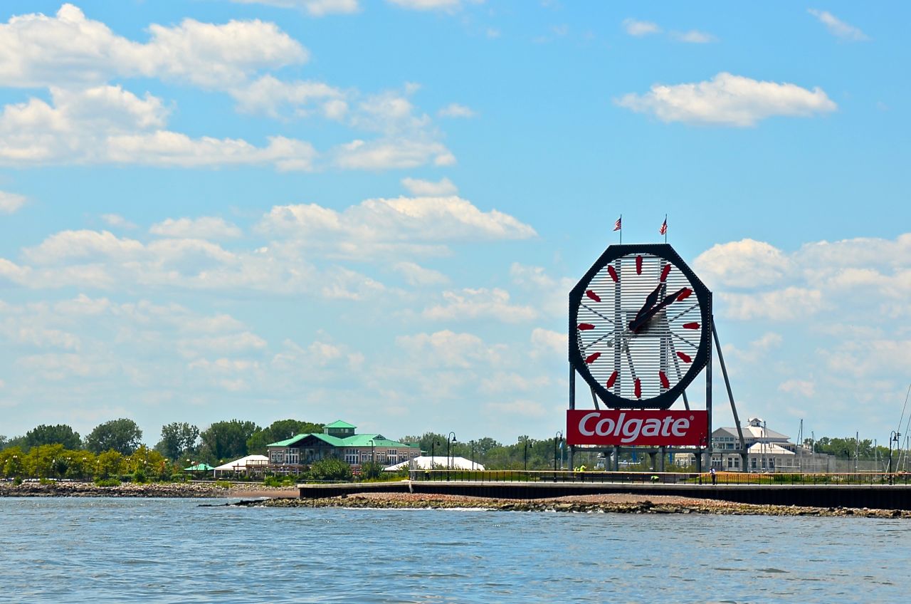
Manhattan’s feared waterway was placid until five minutes before reaching our destination just north of Ellis Island and south of the large Colgate clock on the New Jersey shore. Liberty Harbor Marina is directly across from the new World Trade Center. Here, as the Hudson River narrows, many different craft converge. Sail and human powered vessels mix with petroleum propelled boats; some slowly pushing bulk commodities against the current, and others whisking commuters and tourist alike at 40 mph in every direction. I kept a steady course and warned Charlotte to hold on.
A sharp right turn and we were in the calm waters of a cut dug out of the Hudson River’s New Jersey shoreline. To the right a large mega yacht harbor with country club flair. Further down looks decidedly industrial: cranes, barges, and multiple aged tugboats piles up like so many rubber ducklings. And then there was our marina.
Earlier in the day when making a reservation we were instructed to tie up on the fuel barge of the Liberty Harbor marina. The barge was right out of Road Warrior. It looked menacing. I get my binoculars out and scan the dock looking for anything sharp and once I am satisfied it is safe, proceed. The dock is rotting, the steel is rusted, and the center has more pipes than seem warranted for two fuel pumps.

We were told to call the office via VHF radio but of course, this does not work. We try the phone, no one answers. I see an office in the distance when Charlotte finally makes contact. A young woman with a definitive Jersey accents says she is sending security over to help us. No nattily clad boat boy or girl here. The head is pumped and the fuel is topped off. Then the leather and denim security guard unties us and jumps on the bow to guide us to our slip all the while taking selfies with Carrie Rose as a backdrop. Jersey City, NJ was home for the next week.

The allure of New York City is hard to resist. Just when I thought we should stay, it was time to leave. The ebbing tide helped speed us through the maelstrom of the Narrows, under the Verrazano Narrows Bridge and into the wide expanse of Sandy Hook Bay. The ferries that service the Statue of Liberty, Ellis Island, the Battery, and Staten Island complicate this waterway.

There were Coast Guard, New York City, New York State, and New Jersey marine patrols. Tows pushing barges low in the water with recently unloaded fuel from ocean tankers anchor willy-nilly in the bay. Add to this a steady stream of fishermen, both amateur and professional. My radar was useless. Charlotte and I kept up a steady drumbeat announcing what, where and when one of the above was going to collide with us if I did not alter course.

We were closing on the Verrazano-Narrows Bridge when two big blips on the radar made me look up and see two ships girdling each end of the bridge. My plan, once passed the Statue of Liberty, was to hug the western edge of the coast and keep clear of traffic. No cigar. The combined traffic forced us to the middle. Carrie Rose crossed the threshold into Sandy Hook Bay smack in the center of the bridge with a slab sided car carrier to port and a low slung tanker to starboard.

We took a deep breath and independently decided it was time to leave New York behind despite the threat of small craft warning out on the Atlantic. I turned towards the Sandy Hook lighthouse and took a right into the North Atlantic for an unplanned cruise south down the New Jersey coast.
The people of New Jersey are friendly, enterprising, and fanatical anglers. Every boat was, if not a sports fishermen, a variation of one. People fished at the dock and a hundred miles out in the canyons of the Atlantic. It must be a great place to sell fuel. For the most fervent of them, the season runs into December.

Wind and waves, tides and currents, a circuitous inside passage in thin water, massive beach replenishment projects with equipment three miles off shore, and dolphins off Cape May were some of the highlights. Cape May is a charming town. We biked to the bird sanctuary, along the boardwalk, and up and down streets filled with Victorian homes.

Cruising is about the next leg of the trip and one of the legs that generates anxiety is the trip north on Delaware Bay. Several factors play into this. The fact that it is a large bay opened into the Atlantic is one. Then there is the amount of commercial traffic. The current is another factor. The bay is 50 miles long, so it makes trying to move with a favorable current difficult.
The Chesapeake and Delaware Canal is at the northern end of the bay. It is advantageous to time the trip to have a favorable current in the canal but we decided against this approach and stayed at Delaware City, Delaware. It is an old city on a narrow branch of the original canal. Most cruisers overlooked it and keep going south into the canal. We spent a pleasant day and night there, and left at our leisure to transit the canal.

The canal is a big ditch with a small town, Chesapeake City, near the middle. This is where most boats stop for the night. We left Delaware City with the same plan but alas, the dock was full (two boats) and neither of us felt like anchoring in the small harbor off the city dock, so we made the decision to lengthen our trip from 7 miles to 30. Now our next stop was Georgetown, Maryland on the Sassafras River.
It is hard for me to imagine how a large canal can simply vanish but it did. Suddenly, we were on the Chesapeake Bay. This was a cause for celebration but first, we needed to find the Sassafras River and Georgetown. The Elk and Bohemia Rivers are to the east and the Susquehanna River is to the west. We left them behind. We would later return to the Susquehanna River and to another small town that most cruisers neglect, Havre de Grace.
Georgetown lies 8 miles up the Sassafras River. There is no town just multiple marinas. The marina we picked had a store, a pool and a restaurant named for a woman that pushed her luck with the British during the War of 1812 and won, saving her house (now the restaurant) from ruin.
The weather deteriorated. This gave us an excuse to spend another day swimming in the pool. The Chesapeake is many things but swimmer friendly it is not. The water is the color of day old coffee and it is full of eerie white translucent sea nettles or as we know them up north, urchins. There is no jumping off the back of the boat to cool off here.
Our cruise to Havre de Grace required us to backtrack the way we came. The Susquehanna River provides the fresh water that keeps the Chesapeake brackish. The water flows out through a wide shallow bay forcing most boats into a narrow channel that hugs the southern most shore. This shore is made up of the restricted waters of the Aberdeen Testing Grounds. We heard of unexploded munitions just off the coast. Not the best place to anchor.

Havre de Grace made a decision in the 70’s not to let “Big Box” development destroy the town’s character. They succeeded. There are many small businesses unique to the town. A delicious ice cream and candy store, an odd used bookstore with records and movie paraphernalia, not to mention an entire room of Star Wars junk, several restaurants and bars featuring local food and beer, and a street full of Bed and Breakfast accommodations.
We decided to spend the weekend in the Sassafras River and anchored in 6 feet of water at Ordinary Point. Osprey and eagles fished in the shallows around us. A steady stream of large powerboats transited in and out of the river. I should have placed a second anchor off the stern to keep the bow into the waves they created but I did not think of it until we left.
The temperature had been in the 90’s since the northern Hudson River. It finally moderated after a day of thunderstorms. I thought it might be time again to make a pizza or bake bread but I was wrong. The momentary relief from the heat was followed by more heat and humidity.
With a few more days before we were expected at the Island View Marina, our final destination, we started south down the eastern shore of Maryland. The ship channel runs close to the shore, almost kissing it at some points. We stayed to the east of it and watched a succession of what we would later learn to be great anchoring spots pass by on the way to Rock Hall. Rock Hall is a harbor with a mixture of working and recreational boats. It has a peculiar circuitous channel. The center of this large harbor is off limits except to the shallowest of boats. Seems when the harbor was dredged the tailings were dumped in the middle.

If we stayed two days we got the third free, so we did. This small town had the best seafood in the guise of a fresh rockfish sandwich with french fries and coleslaw. I got the bikes off the salon roof and we cycled to the ice cream stand located in the tiny but well-preserved Main Street, the grocery and liquor stores, to West Marine, and rode across to Swan Creek to inspect the other marinas.
Chesapeake Bay is blessed with multiple tributaries and south from Rock Hall, around Hail Point, is the Chester River. We sidetracked to a secure anchorage on the East Fork of Langford Creek on our way 28 miles northeast to Chestertown. Chestertown was founded in 1698 and is still thriving. We met the entire artistic community and even found a Tea Ceremony connection with a fine furniture maker. One artist in particular was so smitten with Carrie Rose that we invited her for a tour.
The spring tide with help from a north wind flooded the marina and a nearby street. We waded through 4 inches of river water on our way to shower every morning. Much of the nearby housing stock was from the 18th Century. All I could think of was the plumbing.
Another tributary of the Chester River is the Corsica River. It is famous as the site of the Washington D.C. Russian embassy’s hide-a-way. Large floodlights marked its location. We motored into the river and spent two quiet days anchored with the only noise being a crop duster doing acrobatics as it sprayed the fields.

When a thunderstorm threatened, I added 20 feet for a total of seventy feet of anchor chain overboard. The storm never materialized, but boating is one of those better-safe-than-sorry pastimes, so no regrets.

While anchored I called the marina to confirm our arrival date. I could tell by the owner’s voice that he had forgotten about us. Mom and pop marinas are welcoming but sometimes the details get lost in the bustle of day-to-day operations.
The shortest route to the marina from the Chester River was through the notorious Kent Narrows. Kent Narrows separates the eastern shore from Kent Island. A cruising guide states, “Kent Narrows is not a passage for the timid”. But Carrie Rose has been through many narrow waters, so I tried not to get anxious. We planned our passage for a quiet Monday morning with a favorable current and made it through the skinny without a hitch.
Once out of the narrows more shallow water awaited us. We made a U-turn around the island and headed north into Crab Alley Bay. On the way into Crab Alley Creek, we passed the remnants of several eroding islands and then Island View Marina’s single T-dock came into view. I backed into a slip consisting of six large pilings and one small pier about a third of Carrie Rose’s length.

To cruise is to be to be flexible and so once again flexibility has been forced upon us by Mother Nature, this time in the guise of Hurricane Joaquin. When my phone lit up with a Maryland area code, I knew it was the end of Carrie Rose’s time on the water. Within hours, she was to be spirited out of the water and onto the supposed safety of dry land. It never happened as I was to be told several days later.
I am writing this in the backyard of my mother-in-law’s home in Sumter, South Carolina. We drove in on the tail end of the “1000 year” flood. Carrie Rose has spent the last six weeks on her own while Charlotte and I returned to Chicago to care for her father and now visit her mother, both ninety years old.
Tomorrow, we will stop in the Blue Ridge Mountains to visit with a friend from chiropractic school and then spend a week readying Carrie Rose for the winter. Carrie Rose is 1500 miles from Chicago passed great and lessor lakes, rivers, canals, locks, and an ocean…what an interesting trip it has been.

No comments:
Post a Comment